")
")
 The GeoTIGG interpretation system is powerful suite of data management and interpretation software that comprehensively satisfies the demanding requirements of geologists and geophysicists. It includes all the software needed for petroleum exploration and production, from initial seismic and well log interpretation to production analysis and reservoir simulation.
The GeoTIGG program system is the result of collaboration between three companies:
- A French company, CGG (Compagnie Générale de Géophysique)
- A British company, TIGRESS
- A Russian company, Geoleader
Based on a state-of-art integrated database management system, program avoids the field data duplication at different stages of interpretation and it is one of the main advantages of the GeoTIGG system.
The GeoTIGG menus and comprehensive on-line manuals are available in both English and Russian.
Methodology and interpretation sequence demonstrate the advantages of the GeoTIGG software:
The GeoRAPID project database (Relational Advance Project Integrated Database) is implemented in the Oracle relational database management system (RDBMS). The combination of a well designed model and the industry's leading RDBMS ensures a high degree of availability, integrity and security of data. GeoRAPID, through continued evolution, represents the most comprehensive data model available today. GeoRAPID includes many thousands of attributes covering all domains from seismic exploration through to production management.
 To load data into the GeoRAPID, the following formats must be presented: SEGY, LIS, BIT, TIF, LAS, Geoshare, OpenWorks, GPS1/3, Z-Map, ISM, EarthVision and Eclipse.
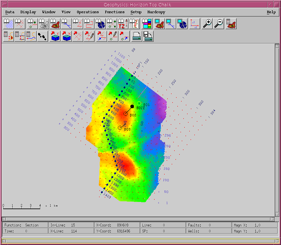
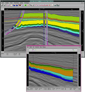
The GeoINT seismic interpretation module provides a complete set of easily accessible applications for the interpretation of 2D and 3D seismic data. These tools, coupled with 3D visualisation, provide an integrated approach for the Geoscientist. Results of the interpretation are saved to the GeoRAPID database for use in the other GeoTIGG applications, for example, GeoCROSS, GeoQC and GeoCART. Standard seismic interpretation is based on Tigress applications; Advanced 3D seismic interpretation is based on CGG applications.
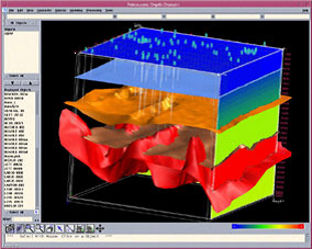
GeoCaem is a unique 3D modeling package designed for a wide range of geological and geophysical tasks. It provides complete modeling of an object (Shared Earth Model) starting from seismic acquisition planning to velocity model building and reservoir characteristics calculation. Thanks to the Shared Earth Model concep, GeoCaem allows fast and exact data conversion from times to depths and vice versa, using different methods including recalculation through the ray model. It also allows geophysicists, geologists and developers to work with one model. You can also use GeoCaem to create a velocity model (SLT) for pre- and post- stack seismic data migration (PSDM).
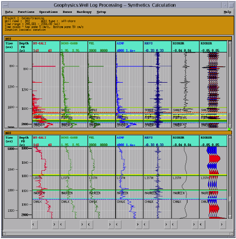 Generation of the GeoSYN synthetic seismograms is used to tie seismic attributes in geological models. The process for generation of synthetic seismograms consists of the following steps: checkshot correction, sonic/checkshot calibration, and synthetic generation calculation.
The GeoTop well log analysis package is designed to process and interpret wellbore geophysics, with the ultimate aim of obtaining petrophysical parameters of reservoir layers. The package is integrated with GeoRAPID database. Input formats: LAS, LIS, ASCII и ZAK, output formats: LAS or ASCII.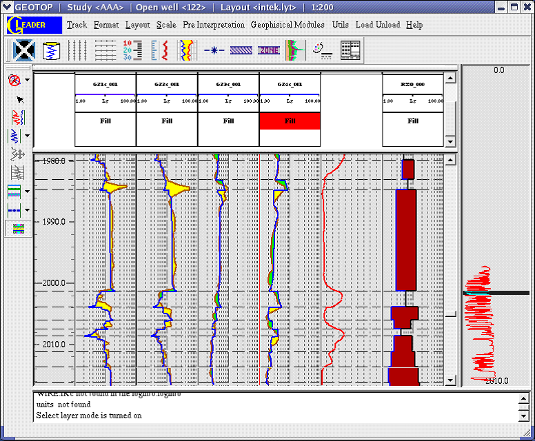
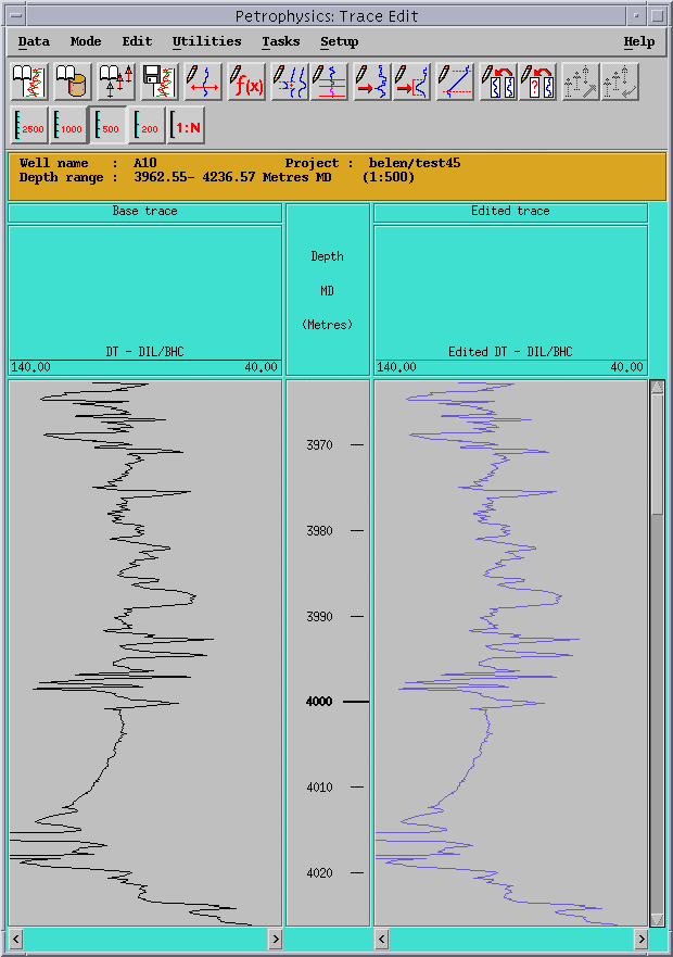
The GeoMUL application is the MultiWell Processing. The GeoTIGG Petrophysics module allows geophysics to analyze data of log, core and to count the reservoir properties. The module provides a set of tools for primary editing of the data logging, the core, the input of borehole corrections and flushed zone, the calculation of petrophysical parameters and data interpretation in open and cased boreholes. While working in the petrophysical module, the different types are assigned to the curves (such as, initial, depth tied, corrected, interpreted and edited. Initial and processed data (curves) are averaged over zones (layers) for further design of the property maps. Automatically record of all the steps for checking and re-processing is made during the petrophysical data processing.
 The GeoMOD/Geology module of GeoTIGG allows the Geoscientist to model the chrono, litho and fluid stratigraphy of the reservoir, using multi-well zonation, correlation and cross-section interpretation. GeoINT, GeoMUL and GeoCART data can be integrated to accurately model the well and inter-well areas. Application hot links with the GeoMUL applications, Cross Plot, Histogram and Cluster Analysis can be used to define finer facies and lithology zonations using core and log data. Results of the interpretation are saved to the GeoRAPID database for use in the other GeoTIGG modules.
The GeoCROSS application is a true depth domain cross sectional tool merging the GeoINT application with the multi-well capability of the GeoMUL application. The GeoCROSS window is used to display and interpret a cross section line and any data lying along the line or within a specified search radius (well data, seismic trace data, seismic horizons, seismic faults, mapping surfaces) in either time or depth.
The main features are:
Cross sectional display of
- seismic data and well data;
- conversion from time to depth;
- horizon and fault interpretation;
- depth only display if no seismic data is present;
- display of the correlation panel between wells;
- editing of the correlation panel;
- communication with the Well Correlation application;
- display of mapping surfaces
- full hardcopy capability
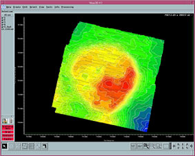
The GeoCART module of GeoTIGG is designed for creating, editing and visualising different maps. The module uses data stored in the GeoRAPID database, originally created in GeoMOD, GeoINT and GeoSIM. GeoCart consists of several interrelated applications that complement each other, forming a simple tool for solving complex geological tasks. GeoCart allows the Geoscientist to model the structural and lithological properties of the reservoir, to create a static model of the deposit, and calculate the oil and gas reserves. The static model can be passed to GeoSIM as the basis for the fluid flow simulation model.
 GeoQC is an independent program used both for the quality control of initial and interpreted data (scatterings and grids) and fast mapping. Also, GeoQC allows performing mathematical operations on data as well as geostatic analysis (crossplots). GeoQC gives the opportunity of simultaneous processing and visualisation of large sets of data. GeoQC is a simple, user-friendly package providing a choice of gridding methods allowing fast, high-quality grid calculation. Grids can be corrected to follow seismic structure (including faults) and to tie with well data.
The GeoSIM module of GeoTIGG provides a wide range of analysis techniques for black oil, compositional, and EOR simulation including thermal modelling, with gas condensate and dual porosity options. Both IMPES and fully implicit time stepping methods are supported for 1D, 2D and 3D models. A unique strength is the use of the integrated project database as the focal point for the compilation and management of the sequence of models required in a simulation study. No keyword files are necessary as all data is stored in the database. The architecture of the GeoSIM module facilitates the use of third party simulators. Tigress Ingeoservice has experience in working both with E&P companies to link in-house simulators and in the use of other industry standard products such as Eclipse, Chears, SURE and the Falcon MPP simulator. A comprehensive set of linked numerical and graphical editors enable the user to display and operate on the data.
GeoPROD is designed to be the E&P Industry's most advanced Field and Well Management IT Tool and was developed as a joint project between the Tigress team and Shell International. GeoPROD is used by the exploration and production industry for the analysis, manipulation and easy visualisation of recent and historical production data. It performs all of the typical objectives of reservoir performance analysis and forecasting, including estimation of original hydrocarbons in place, analysis of past and present performance, prediction of future performance under current conditions, estimation of reserves and recovery rates under various conditions and updating of analysis with new data during life of field. GeoPROD is a client server solution for both UNIX and NT servers and is fully integrated with the GeoRAPID database and other GeoTIGG applications. GeoPROD helps with short-term production gains, for example identification of under producing wells and identification of candidate wells for stimulation treatment and workovers. It is also used for long-term reserves gains through early identification of inappropriate reservoir management studies including inadequate areal drainage and over/under injection. GeoPROD benefits are: increased efficiency and time savings, easy management of large data volumes, quicker identification of production problems, increased production potential.